
Exploring Pittsburgh’s Parks | South Side and Grandview
November 20, 2020
When we arrived at South Side Park the day after Halloween, my roommate and I had already walked 2 miles. It was an unlikely day for an urban hike — the weather forecast indicated a certainty of rain and the sky was a silver grey — but we decided to make the most of it regardless. The winds swept through the half-bare branches of the trees. It was fitting weather for All Hallows’ Day.
Our plan that day was to walk to the South Side from Oakland, cross the Hot Metal Bridge (by far the best way to get into the South Side) and walk through the Flats and Slopes until we arrived in South Side Park. After climbing the rest of the way through the park, we would then pass through Allentown to reach Grandview Park, a part of the larger Emeraldview Park, on the crest of Mount Washington. Multiple city neighborhoods and two city parks over the course of 8 miles certainly seemed like a good hike.
The lower entrance to the South Side Park is situated on Mission Street, partway up the South Side Slopes. The Bandi Schaum Community Garden lies at the bottom of the park, inside of an old baseball field — a shelter with rain barrels stands on home plate and the pitch is filled with rectangular plant beds.
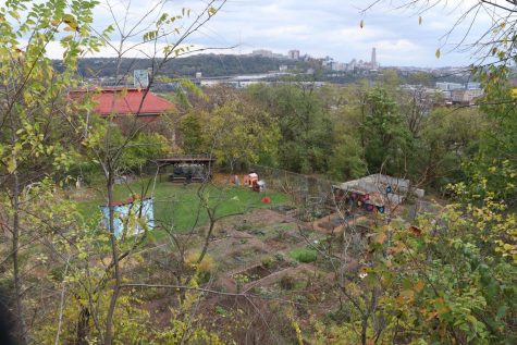
From there, the trails branch off into the park. One climbs straight up into the woods, a sharp ascent which passes by a clearing. On a prior visit in the late summer, I had seen both antlered bucks and the temporary fences meant to enclose the landscaping goats in that open space (but more about those goats when we finally arrive in Frick later in this series). The other trail veers off to the right passing through an open bluff overlooking the repurposed baseball diamond. We took that path and walked until we could see the Flats and Oakland across the river. With the Cathedral against the grey sky, it was certainly a nice view.
Stepping forward to the cliff’s edge to get a landscape shot, I noticed a weathered cardboard sign lying on a stone ledge below. “Anything Helps – T[ha]nx!!” the sign said.
Looking up this park online preceding a handful of bike trips that I took through it earlier this year, I found that its name was almost synonymous with “underutilized,” and to a lesser extent, “underused,” in various restoration reports and informational documents. The first time I visited it, I mistakenly turned down a narrow path at the bottom of the park, believing it to be the trail, only to find the vegetation becoming excessively hard to navigate.
I pushed on, drawn by the blue swatch I saw through the trees — which I expected to be one of the tarps I’ve seen used to cover piles of dirt at other parks I’d visited — only to discover myself standing in a camp of tarps and old tents. Backpacks hung from the trees, and I am ashamed to admit in my surprise and sudden nervousness that they reminded me of the shields of the fallen hanging from tree boughs in Arthurian myths. It was early in the morning, and nobody stirred within the tents. I left quietly, scrambling up a short cliff to return to the main trail.
On that windy day in October, as my roommate and I climbed up the Tombstone trail (a fitting name for the season, I thought), we saw more tarps and tents, and one of their inhabitants sitting on a log. There were now more of the makeshift dwellings than I had first remembered, and higher up on the hill than before. I can only presume that the congregation was caused by the coming winter, and the movement of the camp up the slopes was to avoid the colder early morning air which gathers in hollows.
In the silences between my banter with my hiking partner, I thought about the park’s various patrons — both passersby and temporary inhabitants. Underutilized? Only by a metric that recognized “correct” or legal use of the forested space and prioritized walkers, birders and mountain bikers more than persons experiencing homlessness. I could imagine other standards, some which would have made the South Side one of the most vital parks to human life in the City, as I considered the various ways that different populations — human, or otherwise — use the greens spaces within Pittsburgh as dwellings, refuges, entertainment, laboratories and larders.
The rain began as we left the park via its top entrance, continued on as we walked through Allentown, and happily abated as we reached our second destination on top of Mount Washington: Grandview Park, one of several parks that makes up the sprawling Emeraldview Park.
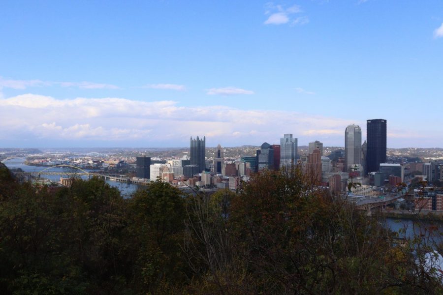
Trees lined the slopes, but through the gaps in the foliage, I could see the dark monolith of the U.S. Steel Tower above the city. Taking the paved trail further east, we came to an open overlook where we could see the entire city and the hills behind it unfolded before us. If I have scoffed at some of the names I’ve encountered within the parks (the various “lakes” spring to mind), I must admit that the name for this park is more than apt.
In my opinion though, the real fun began as we descended from the overlook. After a short stretch of trail, a set of rough steps led down into the forest. Beneath the cover of the trees, the Grandview Trail runs southeast to northwest along the side of Mount Washington, and I’ve found it to be a good place to hike and a decent place for a mountain bike ride. It was fairly level terrain though, at least until we turned off onto the Saddle Trail, which snakes and plunges down the side of Mount Washington.
Squirrels darted among the fallen leaves, and along the side of the trail red berries clustered on bush branches and gleamed in the now-overhead sun. Further down the slope, however, I was reminded that even among the underbrush the most prominent features were often human-made, intentional or otherwise. Among the trees my roommate and I found the detritus of the residential areas above that section of the park, and even the rusting frame of an old car. I made some quip about what future archaeologists might think. My roommate just wondered how the hell it had ended up there.
We went beneath the P.J. McArdle Roadway, passing along a retaining wall covered in multiple layers of colorful graffiti words — an asemic mural. A short stair followed it, and at last the trail dumped us out, unceremoniously, onto the sidewalk that crosses the Liberty Bridge. Our exploration done, we began the long walk home.
Nick Suarez writes about nature and wildlife for The Pitt News. You can drop him a line at [email protected].